Sunday, April 09, 2006
Whales, Osprey & Jelly Fish Arrive
Saw my first Whales in several months on March 26th, Several days before I started seeing Osprey fishing and picking sea grass off the beach to build nests. Yesterday afternoon, went out for awhile and when I came back the beach was covered with blue jelly fish. Looks like Spring has officially arrived, even though the weather still feels rainy and winterlike.


Friday, February 03, 2006
High Wind Warning
After 20 inches of rain in January... Which is double our annual rainfall, and after only having 3 inches of rain last year, a bunch of us our feeling moldy and damp... They promise us clearing next week, but only after the strongest storm of the season....
This is after the one that beat us to death last weekend, and the one in December in which it moved our Pressure treated 60lb picnic bench across the deck....
From the National Weather Service: These Strong South Winds Will Increase Overnight To 45 To 55 Mph With Gusts Of 80 To 90 Mph Especially Along Coastal Headlands And Beaches. Winds In The Coastal Communities Could Gust To 70 Mph OR Higher.
If Conditions Develop As Expected... The Ocean May Reach Low Lying Beachfront Structures... Cause Considerable Erosion Of Beaches... Flood Low Lying Roads And Waysides... And Toss Logs And Other Debris Off Beaches. Abnormally High Tides Will Also Cause Some Tidal Flooding Of Low Lying Areas Along Willapa Bay And Estuaries On The South Washington Coast And Low Lying Areas Along The Oregon Coast. Actual Tides Are Predicted To Reach Near 12 Feet Along The South Washington And North And Central Oregon Coast With The High Tide Around 515 AM Saturday Morning.
Plus we now have the potential to Flood due to High Seas..... I've currently recorded a 42.1mph wind gust stay tuned tomorrow for updates if we still have power and cable...
Soggy Leslie
This is after the one that beat us to death last weekend, and the one in December in which it moved our Pressure treated 60lb picnic bench across the deck....
From the National Weather Service: These Strong South Winds Will Increase Overnight To 45 To 55 Mph With Gusts Of 80 To 90 Mph Especially Along Coastal Headlands And Beaches. Winds In The Coastal Communities Could Gust To 70 Mph OR Higher.
If Conditions Develop As Expected... The Ocean May Reach Low Lying Beachfront Structures... Cause Considerable Erosion Of Beaches... Flood Low Lying Roads And Waysides... And Toss Logs And Other Debris Off Beaches. Abnormally High Tides Will Also Cause Some Tidal Flooding Of Low Lying Areas Along Willapa Bay And Estuaries On The South Washington Coast And Low Lying Areas Along The Oregon Coast. Actual Tides Are Predicted To Reach Near 12 Feet Along The South Washington And North And Central Oregon Coast With The High Tide Around 515 AM Saturday Morning.
Plus we now have the potential to Flood due to High Seas..... I've currently recorded a 42.1mph wind gust stay tuned tomorrow for updates if we still have power and cable...
Soggy Leslie
Monday, January 02, 2006


It's a gorgeous sunny day here at Heceta Beach. We caught a weather break, we weren't supposed to get. While we're still having extremely high surf it appears the Coast Guard decided to take advantage of the clear day and large waves to do some practice boating. Having a front row seat I snapped a series of shots.
Leslie
Friday, December 30, 2005
The Weather Gets Worse.
We had 70mph winds lastnight, the power went off for a couple of hours. There are still a record number of warnings up from the National Weather Service.
Currently we still have a High Surf Warning, a High Wind Warning, A Flood Warning, a Gale Warning and the Siuslaw river has now flooded 2 sections of Hwy 126. It's currently closed at Cushman and Tiernan. Note: it is currently flooding during high tides, so check the tide book before traveling.
It's certainly making for great storm watching.......
Currently we still have a High Surf Warning, a High Wind Warning, A Flood Warning, a Gale Warning and the Siuslaw river has now flooded 2 sections of Hwy 126. It's currently closed at Cushman and Tiernan. Note: it is currently flooding during high tides, so check the tide book before traveling.
It's certainly making for great storm watching.......
Tuesday, December 27, 2005
Coastal Weather Alerts
This could be a record, 3 alerts from the National Weather Service:
FLOOD WATCH IN EFFECT FROM WEDNESDAY MORNING THROUGH THURSDAY AFTERNOON Issue Time: 1:15PM PST, Tuesday Dec 27, 2005Valid Until: 11:00AM PST, Wednesday Dec 28, 2005
* Prolonged Moderate Rainfall Has Fallen Over Western Oregon During The Past Several Days And Has Resulted In Elevated River And Stream Levels. A Very Moist Southwest Flow Across The Pacific Is Directed Toward Northern California And Western Oregon. The Heaviest Rain Will Be In California And Southern Oregon But Enough Rain Is Likely To Reach West Central Oregon That Flooding Is Possible. As A Result Of This Heavier Rainfall A Number Of Rivers Will Reach Bankfull Stage Beginning Wednesday And Continuing On Thursday. It Is Possible That Some Rivers Could Reach Flood Stage. Rivers Of Greatest Concern Are... The Siuslaw River In Lane County...........
HIGH SURF ADVISORY NOW IN EFFECT UNTIL 4 AM PST THURSDAYIssue Time: 5:57AM PST, Tuesday Dec 27, 2005Valid Until: 2:00PM PST, Tuesday Dec 27, 2005
HIGH SURF ADVISORY NOW IN EFFECT UNTIL 4 AM PST THURSDAYCoastal Hazard Message National Weather Service Portland OR 557 AM PST Tue Dec 27 2005 North Oregon Coast-Central Oregon Coast-South Washington Coast- 557 AM PST Tue Dec 27 2005 ... High Surf Advisory Now In Effect Until 4 AM PST Thursday... The High Surf Advisory Is Now In Effect Until 4 AM PST Thursday. Large Swell From A Very Powerful Pacific Storm System In The Gulf Of Alaska Will Arrive Along The South Washington... North Oregon And Central Oregon Coastline Early This Morning. Seas Of 25 Ft Will Subside To Near 20 Feet By This Evening... But Build Again On Wed To Around 28 Feet. In Addition... Tidal Overflow Will Become A Problem Along The South Washington Coast Beginning Tuesday. The Forecast High Tide At Toke Point Is 9.6 Feet At 920 AM. A Combined Storm Surge And Tidal Anomaly Of Nearly 1.4 Feet Will Result In An Actual Tide Of 11.0 Feet. Past Events Have Shown That Tides Of 11.0 Feet Result In Minor Flooding In And Near The City Of Raymond. Tidal Overflow Will Remain A Problem The Rest Of The Week Due To Increasingly Higher Forecast Tides. Another Storm System Will Impact The Coastline Wednesday... Which Could Result In Actual High Tides Approaching 11.5 Feet. The Forecast Highest Tides Are: Wednesday 10.1 Feet At 1004 AM Thursday 10.5 Feet At 1050 AM Friday 10.8 Feet At 1137 AM A High Surf Advisory Means That High Surf Will Affect Beaches In The Advisory Area... Producing Rip Currents And Localized Beach Erosion.
High wind watch in effect from late tonight through Wednesday afternoon.
The Storm Watching has been great don't forget to check the webcam.
FLOOD WATCH IN EFFECT FROM WEDNESDAY MORNING THROUGH THURSDAY AFTERNOON Issue Time: 1:15PM PST, Tuesday Dec 27, 2005Valid Until: 11:00AM PST, Wednesday Dec 28, 2005
* Prolonged Moderate Rainfall Has Fallen Over Western Oregon During The Past Several Days And Has Resulted In Elevated River And Stream Levels. A Very Moist Southwest Flow Across The Pacific Is Directed Toward Northern California And Western Oregon. The Heaviest Rain Will Be In California And Southern Oregon But Enough Rain Is Likely To Reach West Central Oregon That Flooding Is Possible. As A Result Of This Heavier Rainfall A Number Of Rivers Will Reach Bankfull Stage Beginning Wednesday And Continuing On Thursday. It Is Possible That Some Rivers Could Reach Flood Stage. Rivers Of Greatest Concern Are... The Siuslaw River In Lane County...........
HIGH SURF ADVISORY NOW IN EFFECT UNTIL 4 AM PST THURSDAYIssue Time: 5:57AM PST, Tuesday Dec 27, 2005Valid Until: 2:00PM PST, Tuesday Dec 27, 2005
HIGH SURF ADVISORY NOW IN EFFECT UNTIL 4 AM PST THURSDAYCoastal Hazard Message National Weather Service Portland OR 557 AM PST Tue Dec 27 2005 North Oregon Coast-Central Oregon Coast-South Washington Coast- 557 AM PST Tue Dec 27 2005 ... High Surf Advisory Now In Effect Until 4 AM PST Thursday... The High Surf Advisory Is Now In Effect Until 4 AM PST Thursday. Large Swell From A Very Powerful Pacific Storm System In The Gulf Of Alaska Will Arrive Along The South Washington... North Oregon And Central Oregon Coastline Early This Morning. Seas Of 25 Ft Will Subside To Near 20 Feet By This Evening... But Build Again On Wed To Around 28 Feet. In Addition... Tidal Overflow Will Become A Problem Along The South Washington Coast Beginning Tuesday. The Forecast High Tide At Toke Point Is 9.6 Feet At 920 AM. A Combined Storm Surge And Tidal Anomaly Of Nearly 1.4 Feet Will Result In An Actual Tide Of 11.0 Feet. Past Events Have Shown That Tides Of 11.0 Feet Result In Minor Flooding In And Near The City Of Raymond. Tidal Overflow Will Remain A Problem The Rest Of The Week Due To Increasingly Higher Forecast Tides. Another Storm System Will Impact The Coastline Wednesday... Which Could Result In Actual High Tides Approaching 11.5 Feet. The Forecast Highest Tides Are: Wednesday 10.1 Feet At 1004 AM Thursday 10.5 Feet At 1050 AM Friday 10.8 Feet At 1137 AM A High Surf Advisory Means That High Surf Will Affect Beaches In The Advisory Area... Producing Rip Currents And Localized Beach Erosion.
High wind watch in effect from late tonight through Wednesday afternoon.
The Storm Watching has been great don't forget to check the webcam.
Monday, December 26, 2005
Tsunami Siren and Test
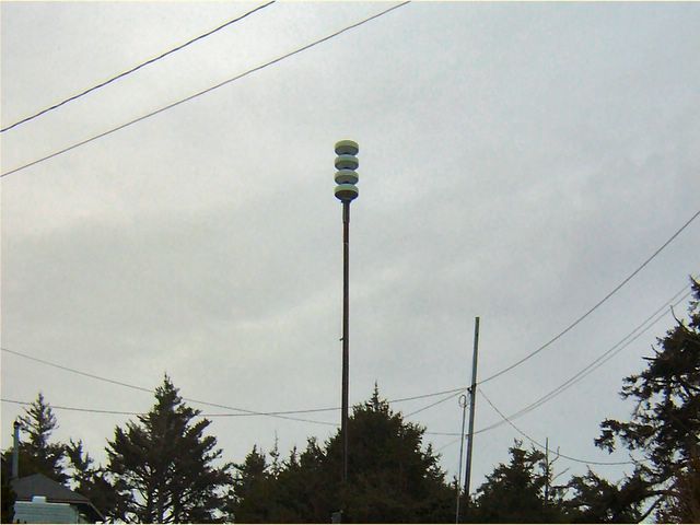
The New Tsunami Siren for the Heceta Beach Area. Located on 3rd Ave it seems to Alert the Neighborhood quite well, according to my neighbors. However it was reported that if you were inside running some kind of appliance vaccum cleaner or hair dryer you couldn't hear it. The City will be working on this.....
From the City's Website:Emergency Preparedness Officials will be conducting a TEST of the newly installed tsunami sirens on the last Friday of each month at 11:00 a.m. The next test is scheduled for Friday January 27th at 11:00 am. The test will not exceed 5 minutes and no action is required from the community. The test tone is one long steady sound. Please do not call 9-1-1. Should this be a real time event where an evacuation is ordered, the sirens would be activated and you would hear a wail tone. The wail tone will vary from high to low warble and run continuously for as long as needed. Once an “all clear” is ordered, the Winchester Chimes will sound for one minute, and then there will be a two minute grace period. This process will run a total of five sets.
Subscribe to:
Posts (Atom)